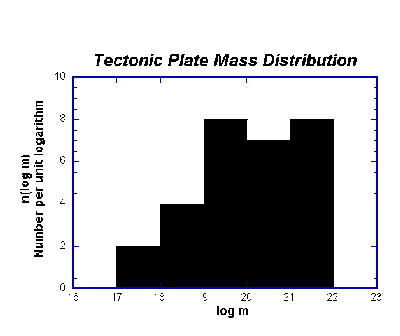
Figure1. Histogram showing the number of plates per logarithmic mass
interval.
We tested this hypothesis by starting out with the National Geographics excellent map (April 1995) entitled "The Earth's Fractured Surface," which presented all the known boundaries of the earth's tectonic plates. From this Winkel Tripel Projection, we replotted the boundaries on equal-area projections: the Peters projections to about 60o N and S latitude, and the Lambert projection of both poles. We measured the areas of 30 plates with a precision planimeter, and thus obtained the area of each plate in square kilometers (Table 1). We then estimated the thickness of each plate to obtain their volumes. Next we estimated the density of each plate to obtain their masses. Finally, we plotted the mass distribution of the plates and compared it to the "sequential fragmentation" theory (Brown and Wohletz, J. Applied Phys 78(4)).
The result was that the mass distribution of the earth's tectonic plates showed a rather broad peak that poorly fit a single Sequential Fragmentation curve (Figure 1). This result indicates that the distribution of tectonic plate masses is not related to a discrete fragmentation mechanism. It also points to the fact that there are too few plates to really perform a distribution analysis of the type we hypothesized.
Assuming that two or more fragmentation events did contribute
to the size distribution of the plates, we simply converted their
area into a length representing their equivalent diameter.
Applying the SFT software, using the conversion in length of 1000
km = 1 mm, we plotted the size distribution (Figure 2) that shows
4 modes that explain over 95% of the observed variance. The
dominant mode (79%) corresponds to major plates, having an
equivalent diameter of 9700 km. The largest plates form a minor
mode (11%) as do the smallest plates (5 and 4 %). All of these
modes with exception of the smallest have positive dispersion
(gamma) values, indicating that aggregation may have played role
in which smaller plates combined early in earth's history to form
larger plates with evidence not manifested by today's
geophysical/geological observations.
Table 1. Plate Area
| Plate | Area (Square Kilometers) |
| African | 61,334,000 |
| Antarctic | 60,916,000 |
| Arabian | 5,010,900 |
| Australian | 47,152,000 |
| Caribbean | 3,319,000 |
| Cocos | 2,860,000 |
| Eurasian | 67,811,000 |
| Indian | 11,920,000 |
| Juan de Fuca | 252,000 |
| Nazca | 15,630,000 |
| North American | 75,888,000 |
| Pacific | 103,280,000 |
| Philippine | 5,447,000 |
| Scotia | 1,651,000 |
| Somali | 16,667,000 |
| South American | 43,617,000 |
| Bismark microplate | 286,000 |
| Burma microplate | 1,110,000 |
| Caroline microplate | 1,720,000 |
| Easter microplate | 133,000 |
| Explorer microplate | 18,400 |
| Fiji microplates | 1,144,000 |
| Galapagos microplate | 12,000 |
| Gorda microplate | 69,600 |
| Juan Fernandez microplate | 96,000 |
| Mariana microplate | 364,000 |
| Rivera microplate | 73,000 |
| Solomon microplate | 254,000 |
| South Sandwich microplate | 166,000 |
|
Tonga microplate |
962,000 |
Figure1. Histogram showing the number of plates per logarithmic
mass
interval.
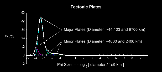
Figure 2. Results using SFT program to analyze subpopulations of
the tectonic plate size
distribution curve. Four subpopulations are evident: Major plates
(>9000 km in equivalent
equivalent diameter) minor plates (<5000 km in equivalent
diameter). The horizontal axis
is a "phi" conversion of plate diameters, and the
vertical axis represents the percentage of the
earth's crust represented by each size mode.
W. K. Brown
5179 Eastshore Drive
Lake Alamanor, CA 96173
K. H. Wohletz
Group EES-1, MS-D462
Los Alamos National Laboratory
Los Alamos, NM 87545