Protecting Northern New Mexico's water
Scientists at the Laboratory diligently monitor storm water coming off of Laboratory property. They have planted wetlands and built structures to keep the water cleaner.
During the initial years of the Manhattan Project, liquid wastes were released into Los Alamos watersheds and canyons. Discharge from the Laboratory was reduced in the early 1950s, and by 1978, with the passing of the EPA’s groundbreaking Clean Water Act and Clean Air Act, the Laboratory began monitoring and remediating the canyons and water run-off in the Los Alamos area. Although the process of sampling and monitoring the watersheds has changed and progressed during the past 40 years, the missions of the watershed quality programs have stayed the same:
• Monitor historically contaminated Laboratory sites
• Monitor current Laboratory operations and prevent contamination
• Evaluate risk to human and environmental health
Currently, the Laboratory monitors seven watersheds that drain into Northern New Mexico’s main source of water and recreational fun: the Rio Grande.
How is surface water monitored and protected?
Monitoring surface water around Los Alamos County requires multiple experts including engineers, hydrologists, chemists, and field scientists all working together under various permits to ensure strict goals are met. The Laboratory follows four permits in conjunction with the National Pollutant Discharge Elimination System:
• Industrial and Sanitary Permit (outfall permit)
• Individual Permit for Storm Water (individual permit)
• Construction General Permit
• Multi-sector General Permit
Watershed monitoring
Although watershed monitoring occurs year-round, the busiest time for collecting water samples is the summer monsoon season (June to September) when rain is frequent. Surface water, storm water, and sediment samples are collected in canyons, active stream channels, floodplains, springs, and other sources by samplers. Samplers are also placed in areas beyond Laboratory property (including the Santa Fe National Forest, Jemez and Española Ranger Districts, and Bandelier National Monument) to establish background levels. Field crews collect water following a flow event (rain or snow melt). In areas that have known historical contamination, extra monitoring occurs to ensure water resources are protected to Environmental Protection Agency and New Mexico Environment Department standards. Samples are analyzed for potential pollutants that include suspended sediment concentration, metals, organics including polychlorinated biphenyls (PCBs), and other select analytes based upon known or potential contaminants. Results are then compared with screening criteria based on the protection of human and environmental health.
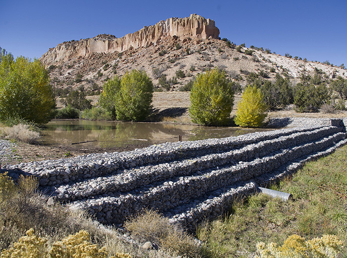
Watershed controls
Engineers design ponds, weirs, grade control structures, wetlands, berms, and riparian vegetation to slow down water that might otherwise erode potentially contaminated sediments. These controls, along with efforts to reduce contamination directly from the Laboratory, ensure the continued safety of the watersheds.

