(PI of "Vadose Zone and Regional Aquifer Flow and Transport Modeling")
Los Alamos National Laboratory (LANL) is a complex site for environmental management. The site encompasses about 100 km2 (37 square miles) of terrain with 600 m (2,000 feet) of elevation change, and an average rainfall of less than 300-400 mm (12 to 16 inches) per year. The site is intersected by 14 major canyon systems. Ecosystems within the site range from riparian to high desert and boast over 2,000 archaeological sites, as well as endangered species habitats. The surface and subsurface water flow discharges primarily along the Rio Grande to the east of LANL. The Rio Grande traverses the Española basin from north to south; several major municipalities use the river water downgradient from LANL for water supply (Santa Fe, Albuquerque, El Paso/ Ciudad Juarez).
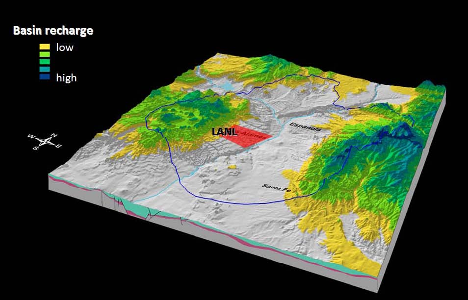
Map of LANL and Espanola basin
Regional quifer beneath LANL
The regional aquifer beneath LANL is a complex hydrogeological system. The regional aquifer extends throughout the Española basin, and is an important source for municipal water supply for Santa Fe, Los Alamos, Española, LANL, and several Native-American Pueblos. The wells providing groundwater from this aquifer for Los Alamos and LANL are located within the LANL site and in close proximity to existing contamination sites. The regional aquifer is comprised of sediments and lavas with heterogeneous flow and transport properties. The general shape of the regional water table is predominantly controlled by the areas of regional recharge to the west (the flanks of the Sierra de los Valles and the Pajarito fault zone) and discharge to the east (the Rio Grande and the White Rock Canyon Springs). At more local scales, the structure of groundwater flow is also influenced by (1) local infiltration zones (e.g., beneath wet canyons); (2) heterogeneity and anisotropy in the aquifer properties; and (3) discharge zones (municipal water-supply wells and springs). The aquifer is also characterized by well-defined, vertical stratification which, in general, provides sufficient protection of the deep groundwater resources.
The vadose zone, between the ground surface and the top of the regional aquifer, is about 180-300 m (600-1000 ft) thick. The vadose zone is comprised of sediments and lavas with heterogeneous flow and transport properties. The variably-saturated flow and transport through the thick vadose zone occurs through pores and fractures, and is predominantly vertical with lateral deviations along perching zones. The groundwater velocities in the vadose zone are high beneath wet canyons (up to 1 m/a) and low beneath the mesas (1 mm/a). Due to complexities in local hydrogeologic conditions, the hydraulic separation between the regional aquifer and the vadose zone is difficult to identify at some localities, especially where mountain-front recharge is pronounced.
The complexity and size of the LANL site make environmental management a continuing engineering and scientific challenge. Legacy contamination—both chemical and radioactive—exists at many locations. Some of the oldest worldwide radioactive Material Disposal Areas (MDA’s), where waste is buried in pits and shafts, are located on the site. LANL is mandated to follow timetables and requirements specified by the Compliance Order on Consent from the New Mexico Environment Department (NMED) for investigation, monitoring, and remediation of hazardous constituents and contaminated sites. Currently, all the remediation activities are scheduled for completion in 2015. LANL is taking actions to prevent potential contaminant effects on human health and the environment.
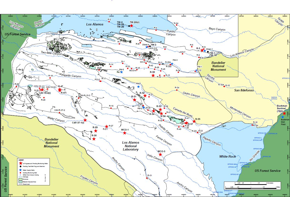
Map of monitoring wells at the LANL site
The environmental work performed at the LANL site is managed by the Environmental Programs (EP) Directorate. A team of external and LANL (Computational Earth Sciences Group, Earth & Environmental Sciences) researchers is tasked by the EP Directorate to provide modeling and decision support to enable scientifically-defensible mitigation of the risks associated with various LANL sites. The principal investigator of this team is Velimir Vesselinov.
Since the 1950's, the LANL site has been the subject of intensive studies for characterization of the site conditions, including regional geology and hydrogeology. Various types of research have been performed at the site related to contaminant transport in the environment which include (1) laboratory experiments, (2) field tests, and (3) conceptual and numerical model analyses. The work is presented in a series of technical reports and peer-reviewed publications.
Currently, important aspects of the environmental management at the LANL site include:
-
design of a long-term monitoring network of groundwater flow and transport in the vadose zone and regional aquifer;
-
investigation of the hexavalent chromium plume in the regional aquifer; and
-
model-based analyses of the environmental impact caused by Material Disposal Areas (MDA’s): performance assessment (PA) and corrective measures evaluations (CME).
Chromium plume in the regional aquifer
A chromium plume has been identified in the regional aquifer beneath the LANL site. Our team has been tasked with providing modeling decision support to the Environmental Programs (EP) Directorate to enable scientifically-defensible mitigation of the risks associated with chromium migration in the environment. Large amount of data and information are available related to the chromium site (vadose-zone moisture content, aquifer water levels, contaminant concentrations, geologic observations, drilling logs, etc.); they are used to develop and refine conceptual and numerical models of the contaminant transport in the environment. The development of numerical models and performance of model analyses (model calibration, sensitivity analyses, parameter estimations, uncertainty quantification, source identification, data-worth analyses, monitoring-network design, etc.) is a computationally intensive effort due to large model domains, large numbers of computational nodes, complex flow media (porous and fracture flow), and long model-execution times. Due to complexities in the model-parameter space, most of the model analyses require a substantial number of model executions. To improve computational effectiveness, our team utilizes state-of-the-art parallel computational resources and novel theoretical and computational methods for model calibration, uncertainty analysis, risk assessment and decision support.
Numerical modeling of flow and transport in the regional aquifer near Sandia Canyon
The numerical model is capturing current conceptual understanding and calibrated against existing data (taking into account uncertainties)
Regardless of existing uncertainties, the model provide information related to:
-
spatial distribution of contaminant mass,
-
contaminant flux to the regional aquifer,
-
monitoring-network design, and
-
environmental risk.
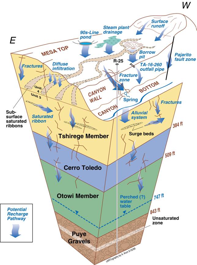
Conceptual model of flow at the TA-16 site
Relevant computer codes:
-
MADS: Model Analysis & Decision Support
-
WELLS: Analytical simulator of drawdowns caused by multiple pumping wells
Relevant publications:
-
Zhang, X., Vesselinov, V.V., Energy-Water Nexus: Balancing the Tradeoffs between Two-Level Decision Makers Applied Energy, Applied Energy, 2016 (accepted).
-
Lin, Y, O'Malley, D., Vesselinov, V.V., A computationally efficient parallel Levenberg-Marquardt algorithm for highly parameterized inverse model analyses, Water Resources Research, doi: 10.1002/2016WR019028, 2016. PDF
-
Mattis, S.A., Butler, T.D. Dawson, C.N., Estep, D., Vesselinov, V.V., Parameter estimation and prediction for groundwater contamination based on measure theory, Water Resources Research, doi: 10.1002/2015WR017295, 2015. PDF
-
O’Malley, D., Vesselinov, V.V., Bayesian-Information-Gap Decision Theory (BIG-DT) with an application to CO2 sequestration, Water Resources Research, doi: 10.1002/2015WR017413, 2015. PDF
-
Lu, Z., Vesselinov, V.V., Analytical Sensitivity Analysis of Transient Groundwater Flow in a Bounded Model Domain using Adjoint Method, Water Resources Research, 10.1002/2014WR016819, 2015. PDF
-
Barajas-Solano, D. A., Wohlberg, B., Vesselinov, V.V., Tartakovsky, D. M., Linear Functional Minimization for Inverse Modeling, Water Resources Research, doi: 10.1002/2014WR016179, 2015. PDF
-
O’Malley, D., Vesselinov, V.V., Cushman, J.H., Diffusive mixing and Tsallis entropy, Physical Review E, doi: 10.1103/PhysRevE.91.042143, 2015. PDF
-
O’Malley, D., Vesselinov, V.V., A combined probabilistic/non-probabilistic decision analysis for contaminant remediation, Journal on Uncertainty Quantification, SIAM/ASA, doi: 10.1137/140965132, 2014. PDF
-
Vesselinov, V.V., O'Malley, D., Katzman, D., Robust Decision Analysis for Environmental Management of Groundwater Contamination Sites, In Vulnerability, Uncertainty, and Risk Quantification, Mitigation, and Management (ed. Michael Beer, Siu-Kui Au, and Jim W. Hall), 2916 pp, ISBN: 9780784413609, doi: 10.1061/9780784413609.197, 2014. Link
-
O’Malley, D., Vesselinov, V.V., Cushman, J.H., A Method for Identifying Diffusive Trajectories with Stochastic Model, Journal of Statistical Physics, Springer, doi: 10.1007/s10955-014-1035-6, 2014. PDF
-
Alexandrov, B., Vesselinov, V.V., Blind source separation for groundwater level analysis based on non-negative matrix factorization, Water Resources Research, doi: 10.1002/2013WR015037, 2014. PDF
-
O’Malley, D., Vesselinov, V.V., Analytical solutions for anomalous dispersion transport, Advances in Water Resources, doi: 10.1016/j.advwatres.2014.02.006, 2014. PDF
-
Heikoop, J.M., Johnson, T.M., Birdsell, K.H., Longmire, P., Hickmott, D.D., Jacobs, E.P., Broxton, D.E., Katzman, D., Vesselinov, V.V., Ding, M., Vaniman, D.T., Reneau, S.L., Goering, T.J., Glessner, J., Basu, A., Isotopic evidence for reduction of anthropogenic hexavalent chromium in Los Alamos National Laboratory groundwater, Chemical Geology, doi: 10.1016/j.chemgeo.2014.02.022, 2014.
-
O’Malley, D., Vesselinov, V.V., Groundwater remediation using the information gap decision theory, Water Resources Research, doi: 10.1002/2013WR014718, 2014. PDF
-
Harp, D.R., Vesselinov, V.V., Accounting for the influence of aquifer heterogeneity on spatial propagation of pumping drawdown, Journal of Water Resource and Hydraulic Engineering, 2(3), pp. 65-83, 2013. PDF
-
Vesselinov, V.V., Katzman, D., Broxton, D., Birdsell, K., Reneau, S., Vaniman, D., Longmire, P., Fabryka-Martin, J., Heikoop, J., Ding, M., Hickmott, D., Jacobs, E., Goering, T., Harp, D.R., Mishra, P., Data and Model-Driven Decision Support for Environmental Management of a Chromium Plume at Los Alamos National Laboratory (LANL), Waste Management Symposium 2013, Session 109: ER Challenges: Alternative Approaches for Achieving End State, Phoenix, AZ, http://wmsym.org, 2013. PDF
-
Vesselinov, V.V., Harp, D., Adaptive hybrid optimization strategy for calibration and parameter estimation of physical models, Computers & Geosciences, doi: 10.1016/j.cageo.2012.05.027, 2012. PDF
-
Harp, D., Vesselinov, V.V., Contaminant remediation decision analysis using information gap theory, Stochastic Environmental Research and Risk Assessment (SERRA), 10.1007/s00477-012-0573-1, 2012. PDF
-
Mishra, P.K., Gupta, H.V., Vesselinov, V.V.; On simulation and analysis of variable-rate pumping tests, Ground Water, doi: 10.1111/j.1745-6584.2012.00961.x, 2012. PDF
-
Mishra, P.K., Vesselinov, V.V., Kuhlmna, K.L.; Saturated–unsaturated flow in a compressible leaky-unconfined aquifer, Advances in Water Resources, doi: 10.1016/j.advwatres.2012.03.007, 2012. PDF
-
Mishra, P.K., Vesselinov, V.V., Neuman, S.P.; Radial flow to a partially penetrating well with storage in an anisotropic confined aquifer, Journal of Hydrology, doi: 10.1016/j.jhydrol.2012.05.010, 2012. PDF
-
Harp, D., Vesselinov, V.V., An agent-based approach to global uncertainty and sensitivity analysis, Computers & Geosciences, doi:10.1016/j.cageo.2011.06.025, 2012. PDF
-
Harp, D., Vesselinov, V.V., Analysis of hydrogeological structure uncertainty by estimation of hydrogeological acceptance probability of geostatistical models, Special issue of Uncertainty Quantification (invited), Advances in Water Resources, doi:10.1016/j.advwatres.2011.06.007, 2010. PDF
-
Mishra, P.K., Vesselinov, V.V., Unified Analytical Solution for Radial Flow to a Well in a Confined Aquifer, arXiv:1110.5940, 2011. PDF
-
Vesselinov, V.V., Harp, D., Decision support based on uncertainty quantification of model predictions of contaminant transport, CMWR 2010: XVIII International Conference on Water Resources, J. Carrera (Ed), CIMNE, Barcelona 2010. PDF
-
Harp, D., Vesselinov, V.V., Identification of Pumping Influences in Long-Term Water Level Fluctuations, Ground Water, DOI: 10.1111/j.1745-6584.2010.00725.x., 2010. PDF
-
Harp, D., Vesselinov, V.V., Stochastic inverse method for estimation of geostatistical representation of hydrogeologic stratigraphy using borehole logs and pressure, invited, Special issue of Stochastic Environmental Research and Risk Assessment (SERRA) Journal celebrating 70th anniversary of Shlomo P Neuman, vol. 24, DOI 10.1007/s00477-010-0403-2, 2010. PDF
-
Vrugt, J., Stauffer, P., Wöhling, Th., Robinson, B., Vesselinov, V.V., Inverse Modeling of Subsurface Flow and Transport Properties Using Recent Advances in Global Optimization, Parallel Computing and Sequential Data Assimilation, Vadose Zone Journal, pp 843-864, 2008. PDF
-
Harp, D., Dai, Z., Wolfsberg, A., Vrugt, J., Robinson, B., Vesselinov, V.V., Aquifer structure identification using stochastic inversion. Geophysical Research Letters L08404, doi:10.1029/2008GL033585, 2008. PDF
-
Miller, T.A., Vesselinov, V.V., et al., Integration of geologic frameworks in meshing and setup of computational hydrogeologic models, Pajarito Plateau, New Mexico Geologic Society Book, pp. 492-499, 2007. PDF
-
Vesselinov, V.V., Uncertainties In Transient Capture-Zone Estimates, Computational Methods in Water Resources XVI, (edited by P. Binning, P. Engesgaard, H. Dahle, G. Pinder & W. Gray), Balkema, Rotterdam, ISBN 90-5809-124-4, pp. 307-314, 2006. PDF
-
Vesselinov, V.V., Robinson, B.A., Delineation of capture zones in transient groundwater flow systems, ModelCARE 2005 Calibration and reliability in groundwater modeling: From uncertainty to decision making (edited by M.Bierkens et al.), pp. 246-252, IAHS Publication 304, ISSN 0144-7815, 2006. PDF
-
Zyvoloski, G.A., Vesselinov, V.V., An investigation of numerical grid effects in automated calibration, Ground Water, (Special issue: Modflow and More 2003: Understanding through Modeling), v.44, no.6, p.814-825, 2006. PDF
-
Davis, P., Hollis, D., Birdsell, K., Vesselinov, V.V., Rives, D., Pozdniakov, S., Los Alamos National Laboratory’s Risk-Based Decision Analysis for Groundwater Remediation and Monitoring, ModelCARE 2005 Calibration and reliability in groundwater modeling: From uncertainty to decision making (edited by M.Bierkens et al.), pp. 297-302, IAHS Publication 304, ISSN 0144-7815, 2006.
-
Vrugt, J.A, Robinson, B.A., Vesselinov, V.V., Improved Inverse Modeling in Geophysics: Combined Parameter and State Estimation, Geophysical Research Letters, v.32, L18408, doi:10.1029/2005GL023940, 2005. PDF
-
Vesselinov, V.V., Estimation of parameter uncertainty using inverse model sensitivities, Computational Methods in Water Resources XV (CMWR 2004) (ed. Miller, C., Farthing, M.W., Gray, W.G., Pinder, G.), Elsevier, ISBN 0-444-51839-8, pp. 508-514, doi:10.1016/S0167-5648(04)80139-4, 2004. PDF
-
Vesselinov, V.V., Keating, E.H., Zyvoloski, G.A., Analysis of model sensitivity and predictive uncertainty of capture zones in the Española Basin regional aquifer, Northern New Mexico, ModelCARE 2002 Calibration and reliability in groundwater modelling: A few steps closer to reality (edited by K. Kovar & Z. Hrkal), IAHS Publication 277, ISBN 1-901-502-07-4, pp. 508-514, 2003.
Relevant presentations:
-
Vesselinov, V.V., O'Malley, D., Katzman, D., Model-Assisted Decision Analyses Related to a Chromium Plume at Los Alamos National Laboratory, Waste Management Symposium 2015, Phoenix, AZ, March 19, 2015. PDF
-
O'Malley, D., Vesselinov, V.V., Bayesian Information-Gap (BIG) Decision Analysis Applied to a Geologic CO2 Sequestration Problem, AGU Fall Meeting, San Francisco, CA, December 15–19, 2014. PDF
-
Cushman, J.H., Vesselinov, V.V., O'Malley, D., Random dispersion coefficients and Tsallis entropy, AGU Fall Meeting, San Francisco, CA, December 15–19, 2014. PDF
-
Bakarji, J., O'Malley, D., Vesselinov, V.V., A Social Dynamics Dependent Water Supply Well Contamination Model, LANL Postdoc Research Conference, 2014. PDF
-
Vesselinov, V.V., Alexandrov, B.A, Model-free Source Identification, AGU Fall Meeting, San Francisco, CA, December 15–19, 2014. PDF
-
Vesselinov, V.V., O'Malley, D., Katzman, D., Robust Decision Analysis for Environmental Management of Groundwater Contamination Sites. ASCE ICVRAM-ISUMA 2014 conference, Liverpool, UK, 2014, (invited).
-
Vesselinov, V.V., Alexandrov, B.S., Deconstruction of groundwater transients using non-negative matrix factorization (NMFt). Computational Methods in Water Resources XX (CMWR 2014), June 10-13, University of Stuttgart, Stuttgart, Germany, 2014.
-
Barajas-Solano, D. A., Wohlberg, B., Vesselinov, V.V., Tartakovsky, D. M., Inverse modeling via linearized functional minimization. Computational Methods in Water Resources XX (CMWR 2014), June 10-13, University of Stuttgart, Stuttgart, Germany, 2014.
-
Vesselinov, V.V., O'Malley, D., Information gap decision theory for monitoring network design. Computational Methods in Water Resources XX (CMWR 2014), June 10-13, University of Stuttgart, Stuttgart, Germany, 2014.
-
O'Malley, D., Vesselinov, V.V., Pore-scale reactions combined with field-scale subsurface contaminant transport. Computational Methods in Water Resources XX (CMWR 2014), June 10-13, University of Stuttgart, Stuttgart, Germany, 2014.
-
O'Malley, D., Vesselinov, V.V., Combining Bayes analysis with info-gap decision theory for environmental management. Computational Methods in Water Resources XX (CMWR 2014), June 10-13, University of Stuttgart, Stuttgart, Germany, 2014.
-
O'Malley, D., Vesselinov, V.V., A method for identifying diffusive trajectories with stochastic models, 6th International Conference on Porous Media & Annual Meeting of the International Society for Porous Media May 27 - 30. Milwaukee, Wisconsin US, 2014.
-
Vesselinov, V.V., O'Malley, D., From pore-scale processes to field- scale contaminant remediation, 6th International Conference on Porous Media & Annual Meeting of the International Society for Porous Media May 27 - 30. Milwaukee, Wisconsin US, 2014, (invited).
-
Vesselinov, V.V., O'Malley, D., Dispersion and diffusion in porous media: From flow field data to upscaled stochastic trajectories, AGU Fall Meeting, San Francisco, CA, December 9–13, 2013 (invited).
-
O'Malley, D., Vesselinov, V.V., What Matters When and Where for Anomalous Dispersion/Diffusion, AGU Fall Meeting, San Francisco, CA, December 9–13, 2013. PDF
-
Vesselinov, V.V., O'Malley, D., Information gap decision support for contaminant remediation, AGU Fall Meeting, San Francisco, CA, December 9–13, 2013.
-
Vesselinov, V.V., Information gap decision support for contaminant source identification. International Symposium on Nonlinear Theory and its Applications (NOLTA2013), Santa Fe, NM, 2013, (invited).
-
Vesselinov, V.V., Katzman, D., Broxton, D., Birdsell, K., Reneau, S., Vaniman, D., Longmire, P., Fabryka-Martin, J., Heikoop, J., Ding, M., Hickmott, D., Jacobs, E., Goering, T., Harp, D., Mishra, P., Data and Model-Driven Decision Support for Environmental Management of a Chromium Plume at Los Alamos National Laboratory (LANL), Waste Management Symposium 2013, Session 109: ER Challenges: Alternative Approaches for Achieving End State, Phoenix, AZ, February 28, 2013. PDF
-
Vesselinov, V.V., Harp, D., Katzman, D., Model-driven decision support for monitoring network design based on analysis of data and model uncertainties: methods and applications, H32F: Uncertainty Quantification and Parameter Estimation: Impacts on Risk and Decision Making, AGU Fall meeting, San Francisco, December 3-7, 2012, (invited). PDF
-
Vesselinov, V.V., Pau. G., Finsterle, S., AGNI: Coupling Model Analysis Tools and High-Performance Subsurface Flow and Transport Simulators for Risk and Performance Assessments, XIX International Conference on Computational Methods in Water Resources (CMWR 2012), University of Illinois at Urbana-Champaign, June 17-22, 2012. PDF
-
Vesselinov, V.V., Katzman, D., Birdsell, K., Broxton, D., Stauffer, P., Harp, D., Miller, Environmental Management Modeling Activities at Los Alamos National Laboratory (LANL), Department of Energy Technical Exchange Meeting, Performance Assessment Community of Practice, Hanford, April 13-14, 2010. PDF
-
Vesselinov, V.V., Harp, D., Koch, R., Birdsell, K., Katzman, K., Tomographic inverse estimation of aquifer properties based on pressure variations caused by transient water-supply pumping, AGU Meeting, San Francisco, CA, December 15-19, 2008. PDF
-
Vesselinov, V.V., Uncertainties in Transient Capture-Zone Estimates, CMWR 2006 XVI International Conference on Computational Methods in Water Resources, Copenhagen, Denmark, 18-22 June 2006 PDF
Relevant technical reports:
-
Groundwater Level Status Report for 2008, LA-14397-PR, 2008. PDF
-
Fate and Transport Investigations Update for Chromium Contamination from Sandia Canyon, LA-UR-08-4702, 2008. PDF
-
Pajarito Canyon Investigation Report, LA-UR-08-5852, 2008. PDF
-
Decision analysis for addressing groundwater contaminants from the radioactive liquid waste treatment facility released into Mortandad canyon, LA-UR-05-6397, 2005. PDF
-
Vesselinov, V.V., An alternative conceptual model of groundwater flow and transport in saturated zone beneath the Pajarito Plateau, LA-UR-05-6741, 2004. PDF
-
Vesselinov, V.V., Logical framework for development and discrimination of alternative conceptual models of saturated groundwater flow beneath the Pajarito Plateau, LA-UR-05-6876, 2004. PDF
-
Vesselinov, V.V., Keating, E.H., Analysis of capture zones of the Buckman wellfield and of a proposed horizontal collector well north of the Otowi Bridge, Hydrogeologic Characterization Program, LANL, LA-UR-02-2750, 2002. PDF

