
by Ken Wohletz
Los Alamos National Laboratory
LA-UR 00-4608
Copyright © 2000 UC
Modern history has its origins in the tumultuous 6th and 7th centuries. During this period agricultural failures and the emergence of the plague contributed to: (1) the demise of ancient super cities, old Persia, Indonesian civilizations, the Nasca culture of South America, and southern Arabian civilizations; (2) the schism of the Roman Empire with the conception of many nation states and the re-birth of a united China; and (3) the origin and spread of Islam while Arian Christianity disappeared. In his book, Catastrophe An Investigation into the Origins of the Modern World, author David Keys explores history and archaeology to link all of these human upheavals to climate destabilization brought on by a natural catastrophe, with strong evidence from tree-ring and ice-core data that it occurred in 535 AD. With no supporting evidence for an impact-related event, I worked with Keys to narrow down the possibilities for a volcanic eruption that could affect both hemispheres and bring about several decades of disrupted climate patterns, most notably colder and drier weather in Europe and Asia, where descriptions of months with diminished sun light, persistent cold, and anomalous summer snow falls are recorded in 6th-century written accounts. Writings from China and Indonesia describe rare atmospheric phenomena that possibly point to a volcano in the Indonesian arc. Although radiocarbon dating of eruptions in that part of the world are spotty, there is strong bathymetric and volcanic evidence that Krakatau might have experienced a huge caldera eruption. Accordingly, I encouraged a scientific expedition to be led by Haraldur Sigurdsson to the area. The expedition found a thick pyroclastic deposit, bracketed by appropriate radiometric dates, that suggests such a caldera collapse of a “Proto-Krakatau” did occur perhaps in the 6th century. Bathymetry indicates a caldera some 40 to 60 km in diameter that, with collapse below sea level, could have formed the Sunda Straits, separating Java from Sumatra, as suggested by ancient Javanese historical writings. Such a caldera collapse likely involved eruption of several hundred cubic kilometers of pyroclastic debris, several times larger than the 1815 eruption of Tambora. This hypothetical eruption likely involved magma-seawater interaction, as past eruptions of Krakatau document, but on a tremendous scale. Computer simulations of the eruption indicate that the interaction could have produced a plume from 25 to >50 km high, carrying from 50 to 100 km3 of vaporized seawater into the atmosphere. Although most of the vapor condenses and falls out from low altitudes, still large quantities are lofted into the stratosphere, forming ice clouds with super fine (<10 micrometer) hydrovolcanic ash. Discussions with global climate modelers at Los Alamos National Laboratory led me to preliminary calculations that such a plume of ash and ice crystals could form a significant cloud layer over much of the northern and southern hemispheres. Orders of magnitude larger than previously studied volcanic plumes, its dissipation and impact upon global albedo, the tropopause height, and stratospheric ozone are unknown but certainly within possibilities for climate destabilization lasting years or perhaps several decades. If this volcanic hypothesis is correct, the global, domino-like effects upon epidemics, agriculture, politics, economics, and religion are far-reaching, elevating the potential role of volcanism as a major climate control, and demonstrating the intimate link between human affairs and nature.
Wohletz KH, 2000, Were the Dark Ages triggered by volcano-related climate changes in the 6th century? EOS Trans Amer Geophys Union 48(81), F1305. (Full Presentation in PDF format)
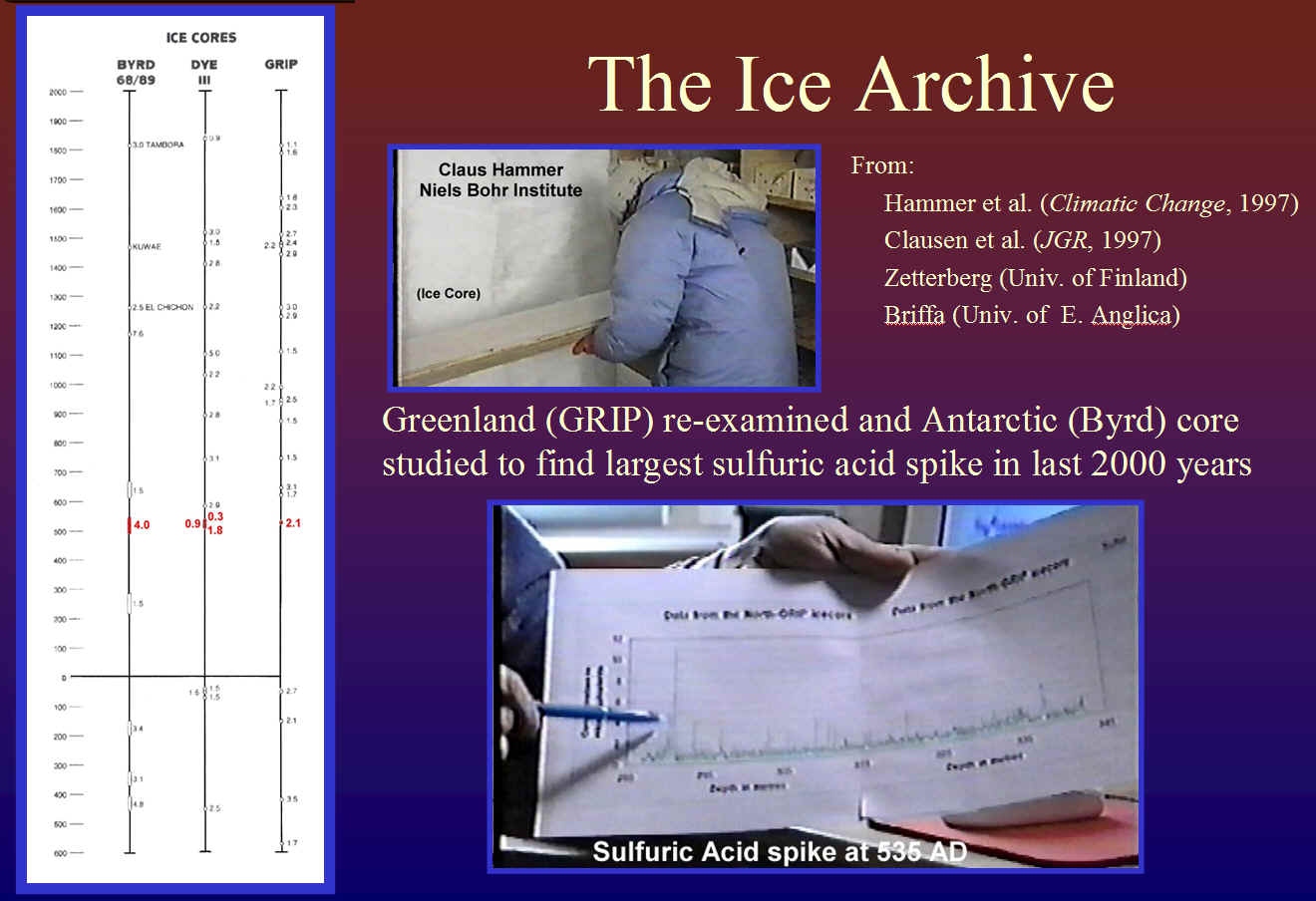
Tree-ring data from Keith Briffa (CRU, Univ. of East Anglia), corroborated by European data compiled by Mike Baillie (Queen's Univ., Belfast), shows clear evidence of a 535 AD climate perturbation, and it is now known worldwide. The origins of this event are likely to have been volcanic since ice core from Greenland and Antarctica show sulfuric acid spikes during this time interval, and for the Byrd core (Antarctica), it is the largest in the last 2000 years. David Keys and I worked with Claus Hammer (Niels Bohr Institute) to reinvestigate the GRIP core from Greenland that Clausen et al. (1997) had already identified.
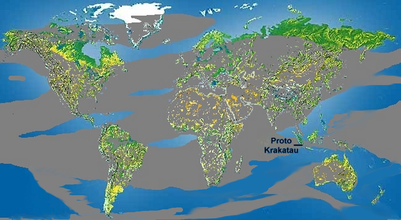
Although asteroid/comet impact remain as potential causes, I focus on a volcanic source located near the equator. Of over 100 potential equatorial volcanoes considered, I found best corroborating evidence in Indonesia, where 6th Century geo-political discontinuity is well documented. Tephra dates are very useful, but there can be pitfalls. For example, some published dates for Rabaul that looked like a fit turned out to be erroneous. It was a translation of the Javenese "Pustaka Raja Purwa" (The Book of Ancient Kings) that alerted David Keys and I to a massive eruption of Krakatau during the 338th year of the Shaka Calendar, which is known to likely be misaligned to the western calendar date of AD 416. We spent considerable time identifying and translating text that could be demonstrated as not having been "contaminated" by post 1883 writings, and in that text is the ancient Javanese tradition of the separation of Java from Sumatra in a cataclysm that fits a description of a large explosive eruption. In other words, a caldera collapse that produced the modern Sunda Straits.
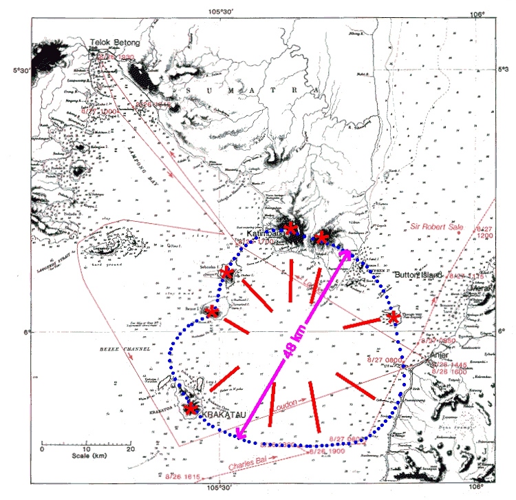
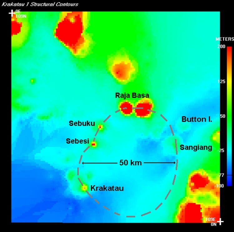
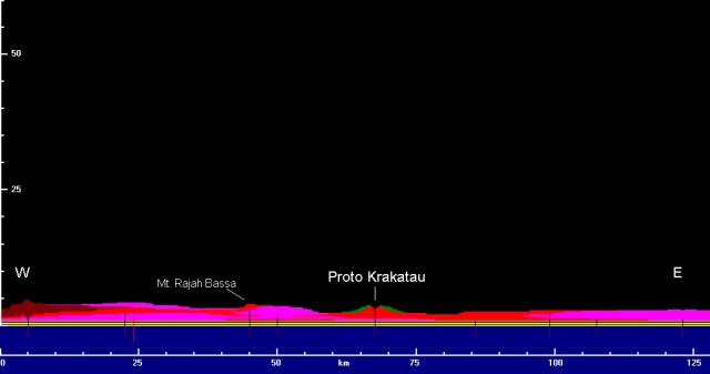
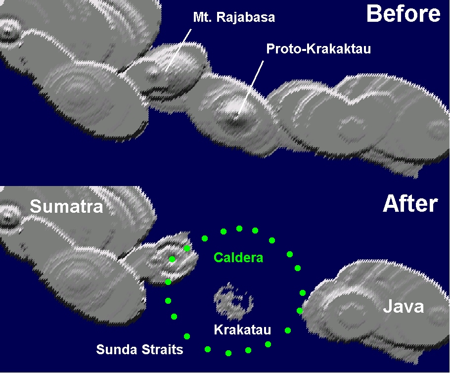
A pre-1883 British Admiralty chart of Sunda Straits shows shallow (~10 m) depths of sea floor in straits, and islands of Krakatau, Bezee, Sebooko, Thwart way, and mountains near Katimbang (Mt. Rajah Bassa); these islands may be vestiges of volcanic vents surrounding the flanks of Proto-Krakatau, the predecessor of the present Krakatau (Krakatoa) volcano. Connecting these vents outlines a caldera with a surface diameter of ~50 km centered in the Sunda Straits about 20 km NE of present day Krakatau.
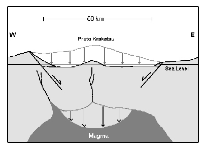
Drawing a west-to-east cross section of hypothetical caldera collapse, shows how Sunda Straits might have formed during the 6th century eruption of Proto Krakatau.
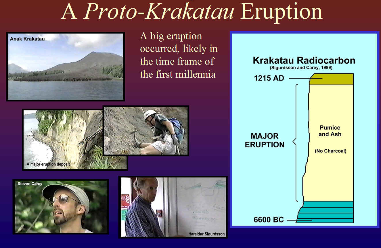
In order to test this Proto-Krakatau caldera hypothesis, I arranged through the UK Channel 4 to fund an expedition in 1999 to the Sunda Straits. I asked Haraldur Sigurdsson and Steven Carey to undertake this effort because of their familiarity with the region. They succeeded to find a pumice and ash deposit from a large explosive eruption that carbon dating bracketed between 6600 BC and 1215 AD. Certainly not conclusive, but indicative of the difficulties in recognizing evidence of old explosive eruptions in a tropical and/or submarine environment.
If one assumes that the average amount of collapse over the entire caldera area averaged ~100 m, then the volume of collapse was approximately 200 km3. This volume is a rough estimate of the amount of magma evacuated from the magma chamber at a depth of several km below the Sunda Straits, a chamber that might have held over a 2000 km3 of magma at the time of eruption (a cylindrical body 50 km in diameter and several km thick).
The 6th century eruption likely started with widespread tumescence of the ground over an area of a thousand square kilometers around Proto Krakatau, occurring over a period of years and reaching a magnitude of several meters or more near Proto Krakatau. This rising of the ground was likely to have proceeded so slowly that people in the area might not have noticed it, but they would have noticed the ever increasing occurrence of small earthquakes that perhaps were felt every few weeks in the year before the giant eruptions and reached nearly continuous shaking in the weeks before the eruption.
The following illustrations were generated by the volcanic eruption simulator, Erupt3, and they depict cross-sectional views of the Sumatra-Java island arc structure, built up by volcanism over thousands of years, consisting of layers of lava, pumice, and ash (red, magenta, and green colors). Proto-Krakatau is shown as a cone-like structure forming a land area connecting Sumatra to the west and Java to the east.
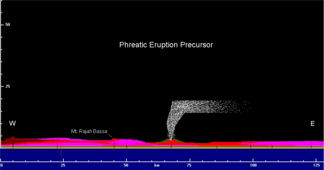
The next series of pictures are snap shots of a computer simulation of eruptive events. The first eruptions were of a type known as “Phreatic,” involving no fresh magma, but rather dust and rocks blown out of the crater of Proto Krakatau by up-rushing steam, which formed by boiling of groundwater below the volcano by the heat of magma as it approached the surface.
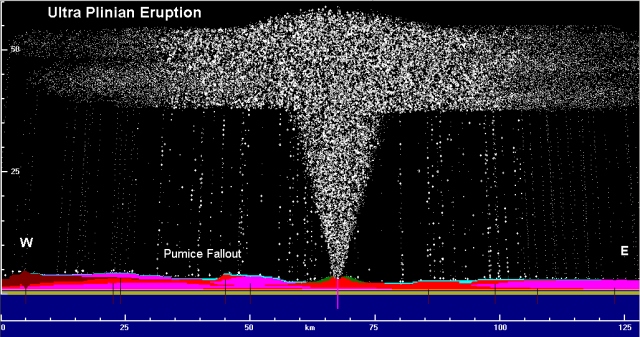
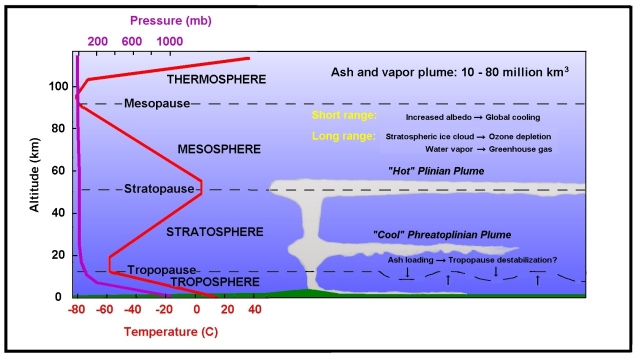
The start of the truly giant eruptions were marked by appearance of stiff, viscous, 900 degrees C magma at the surface that was so highly gas-charged that it exploded out of the volcano with the force of hundreds of nuclear bombs. This explosion, known as an “Ultra Plinian” eruption (after Pliny the elder who witnessed much smaller but similar in appearance phenomena during the AD79 eruption of Vesuvius), drives pumice, ash, and gas as a jet out of the volcano, the jet rising to about 50 km into stratosphere. The speed of up-rushing gas, pumice, and ash likely exceeded the speed of sound, and the jet pushed a shock wave into the atmosphere that raced ahead of the jet at a speed of nearly twice that of sound (~650 m/s). The jet emplaced pumice and ash into the atmosphere at a rate of 100 to 1000 million kg per second, much of it falling from high in the sky to blanket surrounding lands under meters of pumice and ash (light blue layer in illustration below). The jet of pumice, ash, and gas was so hot that it continued to rise as a buoyant plume high into the stratosphere, where it was entrained in stratospheric winds circling the earth from west to east.
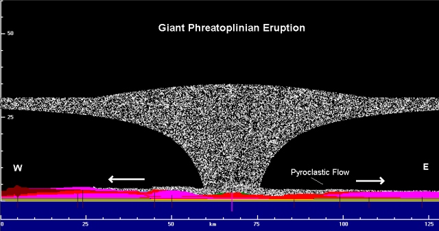
As the Ultra Plinian eruption continued the land under the volcano began to subside, gradually falling into the evacuated part of the magma chamber several km below. With this subsidence, fractures opened around the volcano, allowing sea water to rush into the magma conduit that connected the magma chamber and volcano. This sea water was instantaneously vaporized with additional explosive force, resulting in an eruption called “Phreatoplinian,” which connotes the combination of Plinian eruption with phreatic (near surface) water. The addition of vast quantities of water vapor to the eruption column caused it to collapse on itself, spilling out clouds of ash, pumice, and steam that raced across the surrounding country side at speeds of up to hundreds of meters per second, slowing down to tens of meters per second after traveling about 10 km from the volcano, but continuing to engulf the country side for up to 50 or more km from the volcano. These “pyroclastic flows” completely wiped out all vegetation and any dwelling structures, leaving nothing alive in their wake.
After days to weeks of these Phreatoplinian eruptions, the volcanic fury subsided, leaving a collapse caldera filled by the sea, separating Sumatra from Java, with vestiges of Proto Krakatau barely peeking above the newly formed Sunda Straits
The following before and after cross sections show how the earth’s surface collapsed downward during the 6th century caldera eruption, producing the Sunda Straits, where the Proto Krakatau volcano collapsed below sea level. Note how rock layers and units, shown in various colors, have been displaced downward after the eruption, and a gray-colored layer blankets the topography denoting the pyroclastic flow deposits left by the eruption. The simulated caldera is over 40 km in diameter.

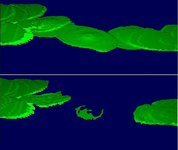
The next illustration shows the 3-D plan view of the simulation results, a view from high altitude above Sumatra and Java. The simulation shows a rough portrayal of the Sumatra-Java island land mass extending from west to east, with the volcanic cone of Proto Krakatau near the center. This island was constructed by the simulated growth of overlapping volcanic cones and lava plateaus, but does not exactly match the coastline of pre-6th century Sumatra and Java. Note that after the 6th century eruption, Proto Krakatau has mostly disappeared, falling below sea level, replaced by a body of water separating Sumatra and Java called the Sunda Straits. From the cross section views above, one can see that the straits are shallow, just covering the sunken volcano. Below, parts of the volcano still protrude above sea level, leaving islands in the straits that are remnants of Proto Krakatau. Perhaps the southern island in the view below is where modern Krakatau will form. Since the 6th century erosion has likely caused some of these islands to fall below sea level, while new volcanic extrusions along the caldera margins have produced new islands, including the present-day Krakatau, which has grown along the southern margin of the caldera. One may also notice a slight change in the coastlines of Sumatra and Java outside of the caldera limits (dotted curve); this change reflects a regional subsidence after the caldera eruption. Although these simulation results are not an exact portrayal of the Sunda Straits, they serve to illustrate the general development of land masses.
While the preceding eruption simulations give a good qualitative picture of how the eruption progressed, we desire more detailed information, specifically regarding the physical parameters of the eruption. Some of these parameters can be constrained by considering the scale of the eruption portrayed above, while others must be calculated. Using the results of supercomputer simulations that solve mathematical equations that express the physical behavior of the eruption, we obtain results that are useful for atmospheric and sound wave models.
Eruption Duration: From the size of the assumed caldera, we showed above that ~200 km3 of magma was erupted. For eruptions of this magnitude, scaling of smaller historical eruptions indicates mass discharge rates of 1 billion kg per second or more. This flux is equivalent to one-one thousandths of a km3 per second or 3.6 km3 per hour. All other parameters being equal, the eruption would have taken at least 34 hours, but owing to waxing and waning fluxes during the eruption, the cataclysmal parts of the eruption might have lasted over 10 days. In fact, such eruptions might occur in day-long pulses, occurring over a period of years.
Eruption Products: Most of magma was fragmented by the tremendous forces of the eruption into pieces of pumice and ash. Especially during the Phreatoplinian eruption, ash was the preferred form of expelled magma. This ash is composed of tiny fragments of rock and glass shards, ranging from about 1 micrometer to a couple of millimeters in diameter. During the Phreatoplinian eruption, as much as 50% of this ash could have been composed of fragments less than 50 micrometers in diameter. Such tiny fragments have exceedingly long resident times in the atmosphere, able to be kept aloft for months by normal atmospheric turbulence. Assuming that 75% of the total 125 km3 of magma were involved with the Phreatoplinian eruption, perhaps as much as 30 km3 of fine ash particles were put into global circulation. Sulfur from the magma likely condensed on ash particles as sulfuric acid droplets, but its abundance is not known.
Water Vapor: Along with the pumice and ash, a lot of water was vaporized and injected into the atmosphere and stratosphere, especially during the Phreatoplinian phase of the eruption, perhaps volumetrically the most important of the cataclysmal phases. For optimum water vaporization, molten magma contains enough heat to vaporize an approximately equal volume of water. Assuming that 75 of the total 125 km3 of magma interacted with water, 75 km3 were vaporized, which upon expansion to atmospheric pressure may have occupied nearly 100,000 km3 of the atmosphere. To be sure, much of this vapor would have condensed an fallen out as ash-clogged rain with in hours of the eruption, but perhaps as much as half of it was carried around the world by stratospheric winds. This vapor would have condensed to form ice crystals, and these ice crystals would disperse in the rarified air to form stratus clouds, darkened by entrained ash. Along with the water vapor from the sea chlorine is also carried into the stratosphere, a component having an important effect on stratospheric chemistry.
Jet and Plume Structure: The jet of ash, pumice, and gas emerged from the vent at supersonic speeds of 650 m/s but decelerated to slow buoyant rise speeds of several tens of meters per second after reaching 10 to 15 km into the atmosphere. The buoyant plume had sufficient energy to continue rising to nearly 50 km before it became neutrally buoyant and began spreading laterally. The width of the jet and plume during the Plinian eruption phase may have ranged from several km at its base to many as many as 40 km near its apex, just below the level where it spread out as a giant anvil-shaped cloud. Ash concentrations within the plume decreased upwards because of admixture of ambient air into the plume as it rose, but these concentrations probably stayed at levels of 1 part in a million by volume. This is a very conservative estimate of total plume volume over the course of the eruption, giving a value of well over 100 million km3 and likely reaching several orders of magnitude larger.
Summary:
Magnitude
Duration
Tephra
Gases
Plume Structure
The global climate impact might involve:
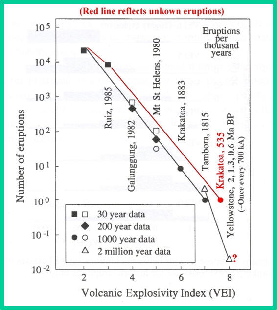
VEI Frequency Plot Revision
The frequency of magnitude 8 eruptions is not considered historical
A 535 Krakatoa (?) suggests a larger frequency of magnitude 7-8 eruptions
Large, historic caldera-type eruptions may not be recognized because of their location in shallow seas or concealed by vegetation
Is Adaptation to Volcanic Crisis Programmed in our DNA?
In 1998 Stanley Ambrose proposed a volcanic winter hypothesis for recent human DNA differentiation
Mitochondrial DNA is passed on by mother; the rate of its mutation is fairly constant over time
Small variation found in today’s population and the number of mutations suggest common ancestors dating back ~70-80 ka (Toba’s eruption)
A “bottleneck” of this DNA suggests reduction of world population to a few thousands (Rogers and Jorde)
Do existing lines carry a “survival” signature?

Conclusions
The historical and archaeological evidence is abundant and so far has stood up to academic review. In fact this evidence is now a major topic for Dark Ages societies
The Proto-Krakatau hypothesis is supported by somewhat more circumstantial evidence
The global atmospheric impact is very hypothetical, requiring new GCM model to approach a perturbation of this magnitude
The global consequences to humanity of a super eruption (Catastrophe) are much more complex and far reaching than has ever been considered. Such an event can fundamentally and permanently change human history
There are numerous potentially active calderas that can erupt in the near future with the magnitude of Proto-Krakatau